
Total Farm Solutions
At Vantage, we offer more than just precision agriculture products; we provide farmers, agronomists, retailers, co-ops and local OEM dealers with precision agriculture expertise for the entire farm. Our brand-agnostic solutions focus on optimizing the efficiency of your farm equipment, seed or chemical use, and support a hassle-free experience for farmers and their service providers implanting advanced technology solutions.
Planting
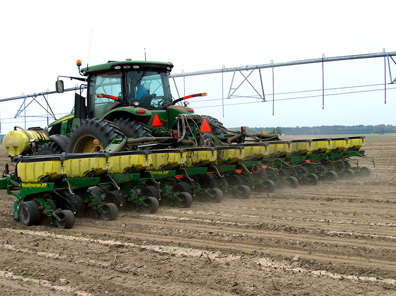
Planting seed in the right place and the correct depth is crucial for a successful yield and return on investment. Our precision planting solution allows you to create planting maps (based off data) in the office and then accurately deliver them in the field. Precision planting assures seed placement exactly where you want it while saving money by avoiding where you don’t.
Featured Products & Services
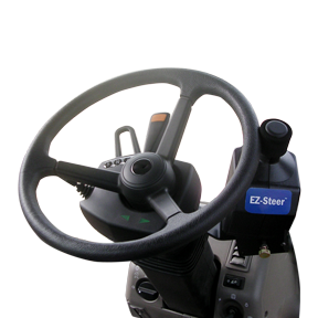
EZ-Steer Steering System
Key Features
- Provides hands-free guidance for your many farm vehicle types
- Allows for unrestricted manual steering when assisted steering is not engaged
- Utilizes terrain compensation technology for high accuracy on difficult terrain
- Easy installation and transferability from vehicle to vehicle
- Compatible with any Trimble® display
- Ideal for broadacre farming applications where extremely accurate positions are not required
Field-IQ system
Key Features
- Variable rate application control
- Automatic section control
- Boom height control
- Seed monitoring
- Spinner speed control
Farm Works
Key Features
- Print a variety of maps and field record reports
- Create, edit, and manage guidance paths
- Design basic and advanced prescription maps
- Analyze profit maps to verify which parts of the fields are more profitable
- Compatible with a wide range of precision farming displays.
Data Management
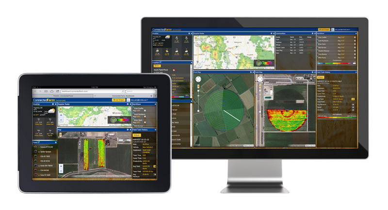
Farms nowadays generate massive amounts of data and it can be difficult to keep track of it all. Put your data to work for you with our data management solutions, tailored to fit your needs. Whether you are wondering where and how to start implementing technology on your farm, or whether you are searching the market to find the best option to address your identified issues, Vantage Southeast can help you.
Featured Products & Services
Getting Started with Data Management
Begin putting your data to work for you.
- Generate basic reports to begin crop record keeping
- Map your field boundaries
- Input and view scouting reports

Full Integration Data Managment
Begin to seriously impact the growth, accuracy and predictability of your operation when the professionals at Vantage Southeast set up your entire operation online. The end goal is to be able to click on any field and understand all operations and costs for any given growing season. To get to this point, these are some of the features that can be added:
-
Add information such as machine and implement fleet, input prescriptions, rental and purchase information, crop information, annual yields
-
Wireless data transfers between the office and Trimble displays
-
Custom dashboard layout for weather, commodity cash bids and futures prices and more.
-
Share your information with your trusted farm advisors
-
Add maps such as irrigation, soil sample, irrigation and yields
-
Irrigation Controls: Monitor and Control, Section Control up to Full VRI Controls on your Pivot, Reporting
-
Soil Sampling, Fertility Management and Prescription Applications - VRA
-
Weather Monitoring and Record Keeping
-
Task Application Recording from In Field Devices on Machines. For example, the planter in the field running a Trimble display will collect the seed variety, amount of seed and cost per asset. You begin to know true costs per acre per application, including cost for the tractor, planter, seed and any other inputs.
Drainage
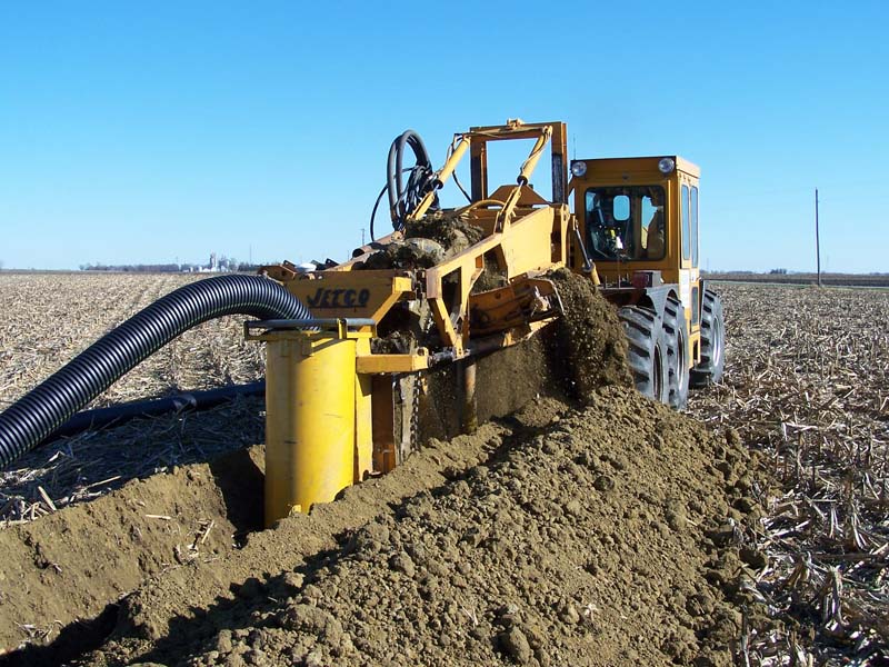
Improper field drainage can result in major crop damage significantly reducing your return on investment. Our drainage solution allows you the ability to survey, analyze, design and install surface and subsurface drainage to properly move water across your field to control ponding and optimize root depth.
Featured Products & Services
WM-Drain Farm Drainage Solution
Key Features
- Seamless, integrated solution for survey, analysis, design, installation, and mapping steps of surface and subsurface drainage projects
- Surface software for analysis and optimal 3D drainage design
- On-the-go design capabilities
- T3™ Enhanced Terrain Compensation Technology for roll-corrected 3D positioning
- Wireless data transfer between the farm office, vehicles, and workers in the field
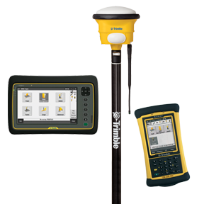
WM-Topo Survey System
Key Features
- Internal radio available with either 900 MHz or 450 MHz frequency options
- Ultra-rugged housing built to withstand harsh conditions
- 440 channel GPS and GLONASS receiver
- GNSS receiver, antenna, battery, and radio in one unit
- Bluetooth® connections enable wireless communication between GNSS receiver and Yuma® 2 or Nomad® handheld computers
- USB host connection for memory stick
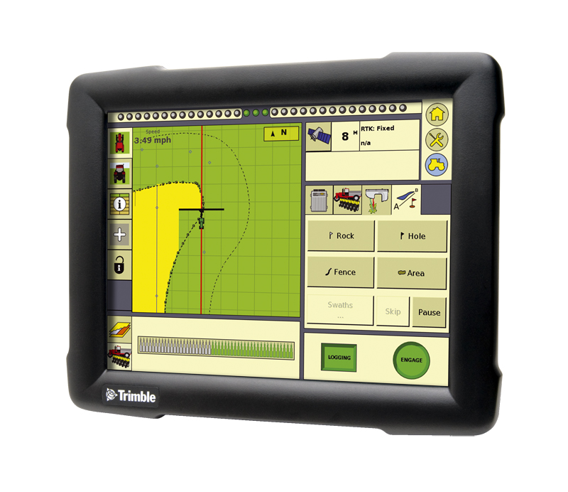
FmX Integrated Display
Key Features
- Rugged construction for everyday field use
- Large 12.1” color touchscreen
- Intuitive user-interface
- On-screen guidance LEDs
- Four video camera inputs
- Two built-in GPS receivers
- GLONASS ready
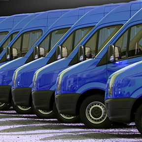
Fleet Solutions

Trimble Field Service Management (FSM) provides visibility into field and fleet operations so businesses can streamline efficiency and increase productivity, while providing service excellence with every job.
For businesses performing mission-critical field service, our solution suite includes fleet management, work management and scheduling, worker safety and mobility solutions that transform the effectiveness of work, workers and assets in the field, all from one fully-integrated platform. Learn more about our cloud-based platform and how our solutions work together to enable an end-to-end field service workflow.
Featured Products & Services
Fleet Management
Fleet Management offers a range of on-demand information and activity reports on key data such as vehicle location, condition and mileage. In addition, Fleet Management includes exception alerts which highlight issues such as when a vehicle hasn’t moved or leaves its designated work area. With this visibility in to fleet operations, businesses can manage fleet performance and costs, running the most efficient fleet possible.
Key Features
- View the real-time status and locations of your vehicles and field technicians
- Exception alerting - Includes speeding, idle time, landmark entry/exit, stop count and duration, distance driven, off-hours use
- Vehicle diagnostics - offering real-time and retrospective reporting on fuel, carbon, odometer and fault codes
- Configurable Reporting - on demand or scheduled
- Scheduled notifications for vehicle maintenance
- Data integration to other existing business solutions
- Direct communications to drivers including messaging and mobile forms
Key Benefits
- Increase fleet productivity using real-time location intelligence.
- Decrease fuel costs by reducing unauthorized vehicle use, curbing excessive speeding and lowering idling.
- Manage maintenance schedules which reduce vehicle wear and tear, lowering the risk of mechanical failure.
- Identify activity that causes excessive carbon emissions such as speeding, excessive idling and route deviation.
- Improve fuel economy and reduce repair costs through proactive engine monitoring and maintenance.

Trimble Fieldmaster Logs
Managing an organization that operates a fleet of vehicles can mean complying with strict Department of Transportation (DOT) Hours of Service (HOS) regulations. The DVIR tool quickly walks drivers through a checklist before taking the vehicle on the road to ensure tires, brakes, mirrors and other vehicle parts are functioning properly.
Features
- Real-time electronic record keeping of HOS/DVIR activities
- Support for FMCSA 395.15 standards for monitoring
- Hours of Service
- Support for FMCSA 396.11 standards for driver vehicle inspection record keeping
- Automatic calculation of driver availability based on assigned rules
- Easy access to driver's’ duty status and driving history
- Record storage in compliance with FMCSA requirements
- Driver alerts to warn of possible violations
- Advanced DVIR capability to confirm vehicle inspections
Benefits
- Reduce errors by automating entry of duty time
- Improves operations with increased back office visibility
- Increases productivity by eliminating time-consuming manual logs
- Increases profitability by mitigating non-compliance fines and penalties
- Reduces audits with on-demand driving data and 6 months of archived reports
- Increases accuracy with electronic filing
- Accelerates and simplifies inspection for compliance officials
- Provides peace of mind knowing compliance regulations have been met
- Delivers best-in-class user experience for logging hours of service
Trimble Asset Tracking
Trimble Asset Tracking offers a range of on-demand information and detailed activity reports on key data such as asset location,speed, stop time and utilization time. It also reports on disconnect events, alerting users if a unit has been disconnected from its main power supply, has been stolen or is being used at an unauthorized time.
With the visibility in to where towed assets are and how they are being used, businesses can better manage asset performance and costs to run the most efficient field operation possible.
Features:
- Live Map - View the real-time status and locations of your towed, powered and non-powered Assets
- Integrated - Integrates with Trimble Fleet Management to view your vehicles and assets within one interface
- Utilization Reports - Enables you to generate high level utilization reports for an individual or group of assets within one interface
- Rugged Device - Features a rugged design and construction to be used outside for multiple assets (i.e. refrigerated trailer, generator, pump)
- Long Life Battery - Offers sophisticated, long life and rechargeable battery that can emit location alerts for up to 3 months on a single charge
- Real-time Alerts - Sends a real-time alert if a unit changes location or has been disconnected and offers wakes on motion for instant location reporting
- Allows you to view the location and status of your towed, powered and non-powered assets. (5 minute updates when towed. Once per day when stationary)
- Integrates with Trimble Fleet Management to view your vehicles and assets within one interface
- Enables you to generate high level utilization reports for an individual or group of assets across multiple locations
- Features a rugged design and construction to be used outside for multiple powered and non-powered assets (refrigerated trailer, generator, pump)
- Offers sophisticated, long life and rechargeable battery that can emit location alerts for up to 3 months on a single charge
- Sends a real-time alert if a unit changes location or has been disconnected
- Wakes on motion for instant location reporting
Benefits
- Enables complete convenience with visibility in to asset usage and location in one place from an online portal
- Offers simple deployment with anytime, anywhere access
- Allows vehicle fleet location to be viewed alongside assets for more effective assignment
- Ensures maximum utilization of assets by monitoring productivity rates
- Improves optimization by identifying idle and rarely used trailers to reallocate
- Allows stolen assets to be located or unauthorized use to be identified through real-time alerts
- Provides dependable, rugged hardware with quick and easy self-installation and de-installation
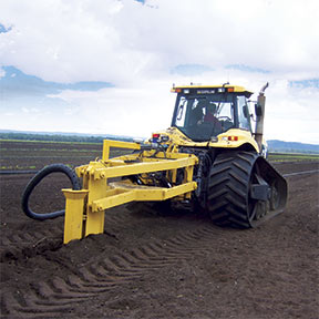
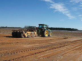
Land Leveling

How water moves across a field is just as important as water itself. Our land leveling solution enables you the ability to streamline the survey, design, and leveling steps necessary to effectively level your field to the necessary slope. Ensure your crops have the adequate amount of water they require to get the most out of your investment.
Featured Products & Services
FieldLevel II
Key Features
- Efficiently distribute water by maintaining grade
- Improve yields by controlling excess water
- Minimize water costs and improve farm productivity
WM-Topo Survey System
Key Features
- Internal radio available with either 900 MHz or 450 MHz frequency options
- Ultra-rugged housing built to withstand harsh conditions
- 440 channel GPS and GLONASS receiver
- GNSS receiver, antenna, battery, and radio in one unit
- Bluetooth® connections enable wireless communication between GNSS receiver and Yuma® 2 or Nomad® handheld computers
- USB host connection for memory stick
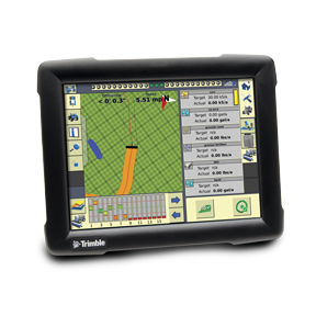
FmX Integrated Display
Key Features
- Rugged construction for everyday field use
- Large 12.1” color touchscreen
- Intuitive user-interface
- On-screen guidance LEDs
- Four video camera inputs
- Two built-in GPS receivers
- GLONASS ready
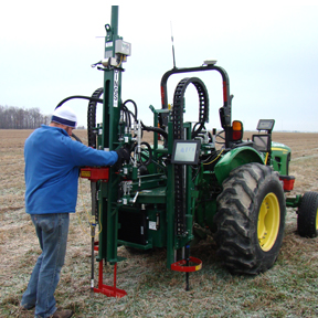
Soil Analysis
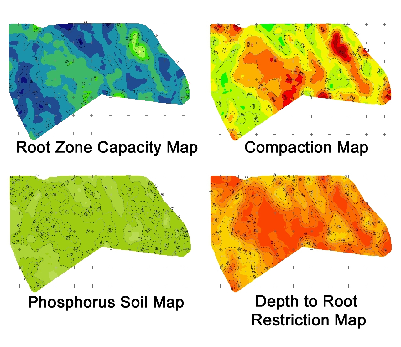
Soil sampling is extremely valuable when determining the optimal amount of inputs required for an efficient and economic crop production. Our state- of-the-art soil sampling solution generates rich data like soil texture, compaction, moisture retention, water availability and soil fertility at the level of detail you need. From EC testing to core samples, we can provide all of your soil sampling needs and the ability to securely share the data with your crop consultant or advisor.
Featured Products & Services
Soil Sampling/Soil Information System (SIS)
By providing a greater understanding of the physical and chemical characterization of the soil, including how inputs move through the soil, SIS enables farmers’ trusted advisors to implement more effective solutions to resolve the unique challenges of each area of their fields. This information can be used to make critical farm management decisions with irrigation, drainage, fertility, and more.
Farm Works
Key Features
- Print a variety of maps and field record reports
- Create, edit, and manage guidance paths
- Design basic and advanced prescription maps
- Analyze profit maps to verify which parts of the fields are more profitable
- Compatible with a wide range of precision farming displays.
Spraying and Spreading
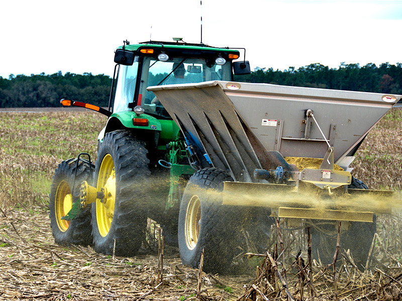
Whether you’re spraying chemicals or spreading fertilizer, the goal is to disperse the optimal amount in the right places. Our spreading and spraying solution allows you to generate prescription maps in the office and then precisely deliver them out in the field. Variable rate spraying and spreading optimizes inputs resulting in a greater return on investment and sustainability your land will appreciate.
Featured Products & Services
FmX Integrated Display
Key Features
- Rugged construction for everyday field use
- Large 12.1” color touchscreen
- Intuitive user-interface
- On-screen guidance LEDs
- Four video camera inputs
- Two built-in GPS receivers
- GLONASS ready
Field-IQ system
Key Features
- Variable rate application control
- Automatic section control
- Boom height control
- Seed monitoring
- Spinner speed control
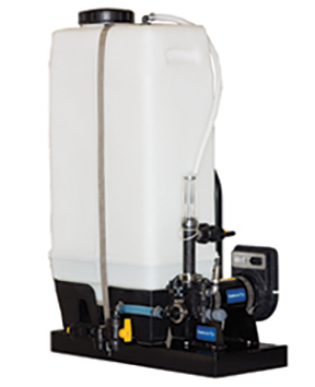
Raven Sidekick Pro
The industry leader in direct injection, Sidekick Pro features:
- High resolution encoder that provides smoother pump control and exceptional lock on target rate technology
- Remote closed-system calibration, eliminating the need for calibration catch tests and exposure to chemicals
- Compatibility with additives that reduce maintenance on your application system
- Low volume capacity of 1-40 ounces per minute
- High volume capacity of 5-200 ounces per minute
- Automatic priming feature
- Real-time diagnostics
- ISO compatible pump
RINSE ASSIST FOR DIRECT INJECTION
- Automatic rinse system that can clean the chemical out with the push of a button
- Three way valve automatically opens to a rinsing agent tank
- Valve automatically returns to chemical tank position at the end of the rinsing cycle
With the Sidekick Pro™ direct injection system, you can save more in time and inputs—and get more for it when applying costly herbicides, insecticides, liquid fertilizer and nitrogen stabilizer. And because there’s no pre-mixing in the tank, there’s no waste from unused product—and no cleanout/disposal issues when you’re done. Watch this video to learn more about how it works!
Harvesting
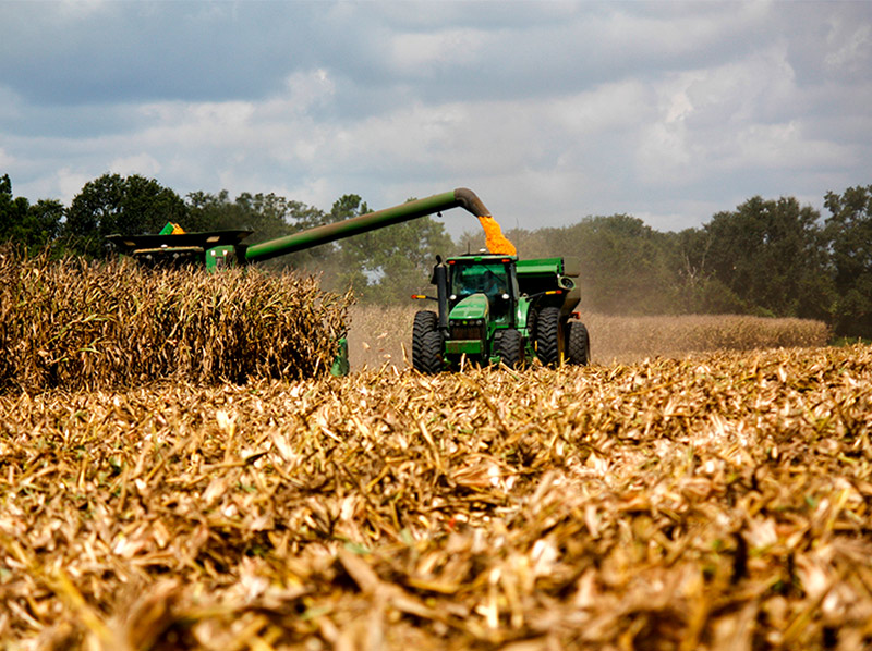
Harvesting is the culmination of all your efforts over the duration of the year. Our harvesting solution allows you the ability to see yield data in real-time and depending on the crop, even moisture data to determine if additional drying is necessary. On top of that, generate yearly records to compare growing seasons and long-term trends to fine-tune next year’s crop.
Featured Products & Services
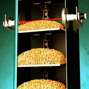
Yield Monitoring
Key Features
- Decrease fuel costs by reducing unauthorized vehicle use, curbing excessive speeding and lowering idling
- Easily identify activity that causes excessive carbon emissions
- Reduce repair costs through proactive engine monitoring and maintenance
- Increase operator performance by monitoring productivity and delays
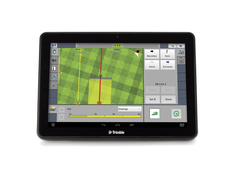
TMX-2050 Display
Key Features
- Rugged construction for everyday field use
- Large 12.1” (30.8 cm) high-definition color touchscreen
- Android-based operating system
- One integrated GNSS receiver
Vantage is a trademark of Trimble Navigation Limited. All rights reserved.